


 24/7 Emergency Service
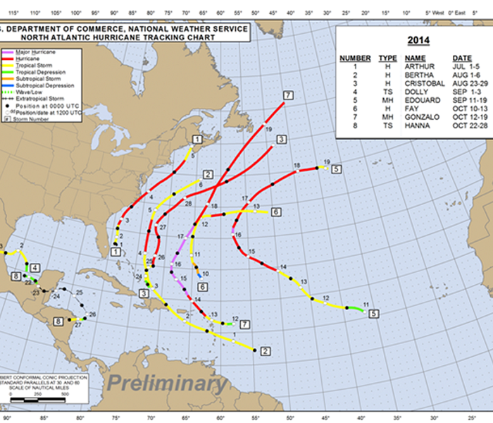
Forecasters Hit The Mark on 2014 Atlantic Hurricane Season- El Nino among factors that results in fewer hurricanes
11/3/2014 (Permalink)
NEW ORLEANS —Philip Klotzbach and William Gray, the hurricane season forecasting team out of Colorado State and the National Oceanic and Atmospheric Administration got this hurricane season right. Both forecast a below-average or near-average hurricane season. That’s what we've had so far;
Two tropical storms (Dolly and Fay), four hurricanes (Arthur, Bertha, Cristobal and Fay) and two major hurricanes (Edouard and Gonzaolo.) The average is 12 storms, six hurricanes and three intense.
The reason less activity was forecast: El Nino was likely to develop. Remember El Nino is the warm water in the east tropical Pacific Ocean that causes strong upper-level winds that take the tops off of developing systems.
El Nino didn't develop. There were some other reasons, too, like cooler Atlantic water temperatures, wind shear and stronger trade winds.
The major players this year: dry Saharan dust, wind shear and strong upper-level lows. I can remember looking at the Atlantic Basin this summer and just seeing, dry sinking air. It was amazing!
Tropical systems need warm, moist air, warm sea surface temperatures, light winds aloft, converging surface winds and an area of rain and storms. That did not happen much this year.
What’s interesting is to see where the storms developed and then moved. From looking at the tracks, we obviously had the Atlantic high in the east Atlantic. We also had all those unusual July and August cold fronts moving off the East Coast of the United States protecting us from storms.
Hurricane Arthur is the only tropical system that hit the U.S., causing a wind gust of 101 mph at Cape Lookout, North Carolina. Arthur moved over the outer banks of North Carolina on July 4.
Bermuda got a double dose of trouble. First it was Hurricane Faye with winds of 80 mph, then a week later the eye of Gonzalo moved right over the island with winds of 110 mph.
It’s like Bermuda was the needle in the haystack. Just over 15 miles long and a mile and a half wide, two hurricanes found Bermuda in the middle of the Atlantic Ocean.
Tropical Storm Dolly moved onshore near Tampico and caused heavy rain. Tropical Storm Hanna hit the Honduras-Nicaragua boarder and caused heavy rain there. The Gulf Coast so far this year has been lucky.
Hurricane season ends Nov. 30. It can’t come soon enough!